The advent of Geographic Information System (GIS) mapping tools and technologies has helped immensely in the processes of identifying, quantifying, and solving problems. GIS collects and analyzes location-based or spatial data. Observational safety data entails collecting, managing, and documenting all available data that relates to the safety of individuals in a work environment. The end goal of using observational safety data is to improve the security and well-being of employees.
GIS, through geospatial analysis, can be used to map out assets and other location-based information. The results of the geo-analysis can be presented in the form of interactive web maps, charts, graphs, and tables. These create an easier way to assess the spatial distribution pattern of observation safety information and allow for the use of functionalities such as real-time tracking. Real-time monitoring streamlines the planning and carrying out of EHS management strategies and procedures.
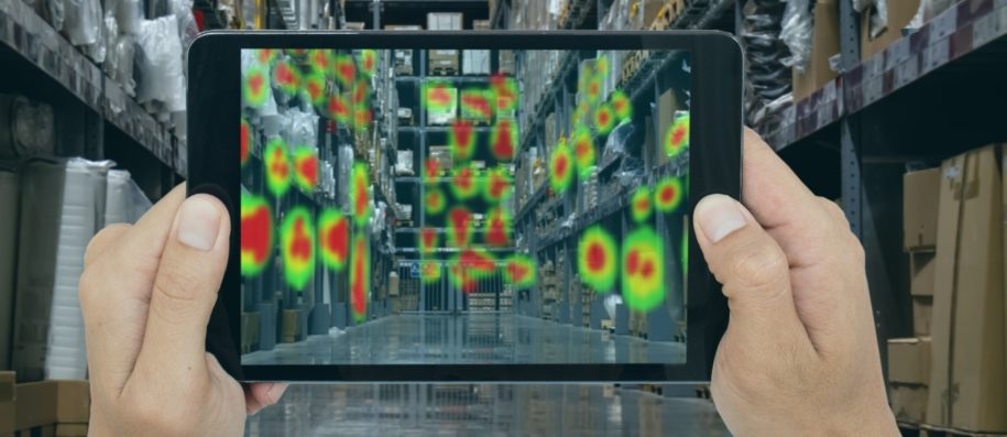
Heat mapping is one such data visualization technique and a relevant tool in the modern geospatial era. Heat maps contribute to EHS decision-making by defining the spatial trends in data which is relevant during regression and other geostatistical analysis. Heat maps can distinguish between low-density, medium-density, and high-density areas of the observational safety data.
One of the pressing issues in observational safety data is the validity of the data collected. The combination of spatial-statistical tools and observational safety data can solve problems concerning location confusion of data through accuracy assessment and computational checks. Furthermore, employing a Global Positioning System (GPS) with heat maps can show areas that require extensive care and attention during environmental hazards and the deployment of preventive schemes. For instance, an organization can make use of population and age groups, previous event locations, and general crime patterns to create a heat map for informing decisions on the allocation of security services during upcoming elections. In the workplace, combining the power of heat maps (spatial-temporal and predictive analysis) with observational safety data means a more advanced risk assessment and mitigation process. With these tools, an EHS manager can create a heat map that compiles operational data (e.g., hours worked, equipment run times, forklift/logistics patterns, traffic patterns, etc.) to create a heat map that serves as an operational decision support system by anticipating the possibility of accidents, areas for improvement, and the timing, location, and focus of inspections to best comply with laws and regulations.
GIS has played a significant role in geospatial tools and methodologies by resolving several prolific EHS issues. GIS, through spatial analysis, has been used to create well-informed EHS strategies. The abilities of GIS to answer questions on where incidents and events occur, measure and quantify the distribution of incidents and events, analyze the relationships and interactions between events and incidents and make predictions based on these existing patterns and trends all have contributed to furthering EHS as a proactive industry. Data visualization through heat mapping can confirm the validity of current safety strategies in organizations, contribute to the observations that improve safety strategies, and identify areas that pose risks to workers and assets.
Author Bio
The SafetyStratus Research Advisory Group (RAG) brings together thought leaders from the global environmental, health, and safety community to promote best practices and provide key insights in the profession and the industries they serve. The Research Advisory Group also advocates, where practical, the intersection of and advances with the use of technology, such as the SafetyStratus enterprise EHS software platform. Group membership consists of representatives from across varied disciplines and market sectors as well as select members of the SafetyStratus team.
The primary objectives of the SafetyStratus RAG partnership are to:
- Build a strategic partnership between EHS practitioners and the SafetyStratus team.
- Provide engaging and practical content to the global EHS community.
- Provide discipline and market feedback specific to SafetyStratus products and services.
While the objectives of the RAG are varied, the primary public-facing outcome will be available through engaging and practical content found on the SafetyStratus resource pages. Various articles, papers, and other valuable resources will be produced and shared as part of an ongoing effort to cultivate a robust community. Ultimately, the SafetyStratus RAG will expand to have a broader reach and provide opportunities for more inclusion by all interested EHS professionals a collaborative community environment.